

Mapping Stories: Geography for Ages 2-6
Want to teach geography to kids aged 2–6? Start with stories.
Research shows stories are 22 times more memorable than plain facts. Instead of rote memorization, storytelling connects young minds to geography by sparking curiosity, building spatial awareness, and introducing cultural diversity. Here’s how:
- Legends & Folktales: Stories rooted in specific places, like the Maori or Aztec creation myths, help kids understand landscapes and human interactions.
- Interactive Maps: Pairing maps with stories lets children follow characters’ journeys, boosting spatial thinking and memory.
- Hands-On Kits (e.g., Global Sprouts): Monthly boxes with crafts, artifacts, and activities make geography engaging and easy for families and educators.
Quick Comparison:
| Method | Strengths | Challenges |
|---|---|---|
| Legends & Folktales | Emotional connection, cultural insights | Requires prep and careful story selection |
| Interactive Maps | Builds spatial skills, hands-on learning | Needs materials and planning |
| Global Sprouts (Kits) | Ready-to-use, multi-sensory activities | Higher cost, best as a supplement |
1. Legends and Leagues
Using legends and traditional stories as a tool for teaching geography is a creative way to connect young children with the world around them. Stories passed down through generations not only make geography more relatable but also create a bridge to understanding different cultures. They transform abstract ideas into vivid, memorable experiences.
Stories Rooted in Place
Legends are deeply tied to the landscapes they describe, offering a window into how cultures view and interact with their environment. For instance, the Maori creation story, The Children of Rangi and Papi, vividly portrays fierce storms, mirroring New Zealand’s dramatic weather patterns. When children hear these tales, they begin to see New Zealand as a place shaped by dynamic natural forces - not just a distant name on a map.
Similarly, the Aztec creation story, How We Came to the Fifth World, recounts the destruction of earlier worlds by natural elements. This narrative highlights the importance of fresh water in the Yucatán, where cenotes are a vital resource. Through this story, children grasp why water is precious and how geography influences daily life.
Australian Aboriginal myths, like Sun Mother Wakes the World, introduce students to diverse landforms while explaining how terrain shapes human settlements. These stories bring Australia’s varied landscapes to life, helping young learners understand why certain locations hold special meaning for the people who live there. Such storytelling combines physical and cultural geography into one immersive experience.
Why Stories Stick
Narratives naturally captivate young learners by weaving characters, conflicts, and resolutions into lessons. This approach not only makes geography more engaging but also improves memory retention. For example, a preschool teacher, Ms. Jones, used children’s books and photos to explore bedtime rituals from around the globe. Her students became fascinated by the diversity of cultural practices, sparking curiosity and connection.
Instead of simply memorizing that Australia is home to unique animals, children remember how Sun Mother Wakes the World brought animal spirits to life against the backdrop of Australia’s landscapes. The storytelling approach transforms facts into experiences, making them far more meaningful.
Challenges in the Classroom
While legends offer rich learning opportunities, adapting them for U.S. classrooms can be tricky. Teachers must strike a balance between cultural authenticity and age-appropriate content. Some traditional stories include themes that may be too complex for young learners, requiring careful selection and thoughtful presentation.
Educators also need a strong understanding of the cultures behind these stories to ensure they’re shared respectfully. Sourcing authentic and suitable legends can take extra time and effort, particularly when classroom schedules are already tight.
How Legends Enhance Geographic Learning
This storytelling approach helps children see geography as more than just memorizing maps and locations. It introduces them to the ways people adapt to and interact with their environment. By hearing stories tied to specific climates, natural resources, and landscapes, young learners begin to understand concepts like human–environment interaction without being overwhelmed by technical terms.
Legends also nurture spatial thinking. Stories like Sun Mother Wakes the World encourage children to visualize distances, directions, and diverse terrains. These mental maps lay the foundation for understanding geographical concepts such as direction and scale.
For this method to succeed, teachers must actively connect the stories to geographical lessons. By highlighting patterns across cultures and landscapes, educators can help children develop a deeper appreciation for the relationship between people and their environments. This narrative-driven approach not only enriches learning but also sparks curiosity and wonder about the world.
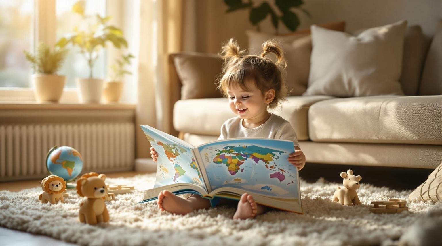
2. There's a Map on My Lap
Pairing maps with storytelling turns geography into an exciting, hands-on adventure for young children, making abstract concepts come to life.
Making Stories Come Alive
National Geographic's "Mapping the Storybooks" activity illustrates how combining maps with character cutouts helps children follow stories across time and space. As kids move toy characters or paper figures across a map, they naturally pick up words like "north", "across the river", or "through the mountains".
This interactive method works especially well because children as young as four can grasp and use maps effectively. A study of 175 children aged two to five found that by age four, kids could use scale models to navigate real-world spaces. Dr. Martin Doherty from UEA's School of Psychology shared that map-reading might be less complex than we think.
Building Spatial Awareness Through Stories
Following characters’ journeys on maps helps children develop spatial skills. Spatial thinking is about understanding how we navigate and solve problems in our surroundings. Stories, by nature, involve spatial elements - characters travel, explore, and interact with different environments. Adding visual maps to these narratives enhances memory better than text alone. Research shows that visual aids like maps improve retention and understanding.
These spatial exercises seamlessly transition into practical classroom activities, making them both fun and educational.
Practical Implementation in American Classrooms
Using maps with stories fits perfectly into early childhood programs in the U.S., catering to various learning styles and attention spans. Teachers can begin with familiar settings - like mapping a character’s journey through a child’s neighborhood or state - before moving on to international adventures.
To deepen understanding, teachers can encourage students to retell stories using maps and positional terms connected to familiar places. Having children move character cutouts along story paths keeps them engaged while reinforcing geographic concepts.
Storyteller and educator Antonio Sacre highlights the value of oral storytelling in this process:
"Telling the story out loud first in your own words to your students before they even read the story gives them rich context and helps them understand what they are going to read, giving them a feeling of success even before they tackle the words. You could also leave out the 'good parts' and get them excited to leap into the text to find out what happens."
Delivering Cultural Context Through Maps
Maps combined with stories are excellent tools for teaching about cultural practices and their origins. They help students understand how and why these practices developed in specific regions, fostering a sense of connection to the broader world. This approach also encourages environmental awareness by showing children their role in a global community.
Keeping Kids Engaged
The mix of maps and storytelling captivates young learners by engaging multiple senses. Kids see the map, hear the story, and physically move characters across the landscape. This multi-sensory approach aligns with how preschoolers naturally learn - through active exploration rather than passive listening. It’s not just engaging; it reinforces important geographic concepts in a way that sticks.
Challenges in Early Childhood Settings
Despite its many advantages, there are hurdles to integrating maps with storytelling. Teachers need maps that are simple enough for young learners to understand but detailed enough to support meaningful stories. Striking the right balance between educational content and entertainment can be tricky, especially in mixed-age classrooms common in many U.S. preschools.
Time is another challenge. Combining maps with storytelling takes more time than traditional reading activities, requiring educators to carefully plan their lessons. However, the payoff is worth it - children retain geographic concepts more effectively through this interactive approach. These insights set the stage for exploring how cultural storytelling can further enrich learning in the next section.
3. Global Sprouts
Global Sprouts delivers monthly culture boxes that bring geography to life through storytelling. This hands-on approach transforms abstract concepts into engaging, story-driven learning experiences.
Story-Driven Geographic Learning
Each box focuses on a specific country, using cultural artifacts to tell its story. For example, the Australia box includes a plush koala, an Indigenous dot painting activity, and photo cards showcasing landmarks like Uluru and the Great Barrier Reef. The Spain box, on the other hand, features a flamenco fan craft and a mosaic project inspired by Gaudí’s iconic designs, blending geography with local artistic traditions.
Multi-Sensory Geographic Engagement
The boxes engage multiple senses to deepen understanding. Take the Guam box, for instance - it includes a coconut shell, a sea turtle art project, and Chamorro language cards. QR codes link to curated music and videos, offering an interactive way to explore the island’s culture and geography.
Practical Use for U.S. Families and Educators
Global Sprouts is designed with busy U.S. parents and educators in mind. Each box comes with all necessary materials, making it easy to dive into the activities. Subscriptions cost $35.99 per month, while individual boxes are available for $29.99. The activities are short and engaging, tailored to fit the attention spans of preschool-aged children in the U.S.
Adding Cultural Depth to Geography
Global Sprouts goes beyond maps and landmarks by incorporating cultural elements through educational booklets, language cards, and artifacts. This holistic approach helps kids see how geography influences daily life, traditions, and customs around the world. It aligns with the growing focus on cultural awareness in early childhood education, encouraging children to develop a global perspective.
Positive Feedback and Portability
Parents and teachers have praised the activities for sparking curiosity and encouraging meaningful interactions. Many projects, like sticker and coloring activities, are also travel-friendly, making them a great screen-free option for families on the move.
Considerations for Classroom Use
While Global Sprouts is a valuable resource, it’s best used as a supplement to a broader geography curriculum. Teachers may need to integrate the activities into their lesson plans, and the monthly subscription format could require some scheduling flexibility. However, the option to purchase individual boxes adds versatility for educators and parents alike.
sbb-itb-6d35b6a
Pros and Cons
Teaching geography to young children through storytelling offers a variety of approaches, each with its own strengths and challenges. Choosing the right method depends on weighing these trade-offs.
| Method | Pros | Cons |
|---|---|---|
| Traditional Legends & Folktales | • Offers rich historical context and cultural depth • Easily accessible, often free or low-cost • Flexible pacing to suit different attention spans • Emotional engagement through universal themes |
• Requires significant preparation and research by the teacher • Lacks visual aids, which may not suit kinesthetic learners • Risk of cultural insensitivity if not handled carefully • Limited hands-on interaction for active learners |
| Interactive Map Activities | • Builds spatial awareness and foundational map skills • Easily adaptable for various skill levels • Encourages movement and active participation • Provides a strong base for future geography learning |
• Abstract ideas may be hard to grasp for children ages 2-4 • Requires materials and preparation time • Can overwhelm with too much information at once • Lacks cultural depth unless supplemented with context |
| Global Sprouts Subscription | • Comes with pre-prepared, ready-to-use materials • Engages multiple senses through crafts and artifacts • Monthly structure helps establish routine • Portable activities suit busy families |
• More expensive compared to free resources • Fixed schedule may not align with all lesson plans • Limited flexibility in selecting specific cultural themes • Functions better as a supplement than a standalone curriculum |
These methods highlight key differences in cost, cultural engagement, and adaptability, which can shape their use in classrooms.
For instance, traditional storytelling thrives on teacher enthusiasm and creativity, but this can demand extra time and energy. Interactive map activities, on the other hand, naturally draw children in through movement and exploration, while Global Sprouts combines storytelling with hands-on materials to keep young learners engaged.
Cultural representation is another critical factor. Teachers using folktales must ensure accurate and sensitive portrayals, which can be challenging without proper resources. Global Sprouts addresses this by curating culturally appropriate materials, but some educators may prefer the flexibility of choosing their own stories.
Adaptability in U.S. classrooms often depends on available resources and teacher workload. Traditional storytelling may require more preparation time, which could be a hurdle for busy educators. Meanwhile, Global Sprouts offers convenience with its ready-made kits but comes at a higher cost.
Managing attention spans is essential as well. While traditional storytelling may struggle to hold the focus of younger children (ages 2-4), interactive activities and Global Sprouts' shorter, hands-on tasks are better suited for keeping kids engaged.
Cost considerations also play a role. Traditional storytelling is budget-friendly, but Global Sprouts offers the advantage of saving preparation time, which some teachers find worth the investment. Finding the right balance between these factors is key to making geography lessons both effective and enjoyable.
Conclusion
Teaching geography through stories and legends creates engaging and meaningful learning experiences for young children, offering an approach that traditional methods often fail to achieve. By blending cultural storytelling, interactive mapping, and hands-on activities, educators can address the diverse learning needs of children aged 2–6, transforming abstract geographical concepts into lessons that stick. These methods are supported by both research and practical classroom applications.
"I believe that when you teach kids geography, they have the final puzzle piece that pulls a lot of their experiences together." - Megan Machucho, Author
Studies show that story-based learning enhances motivation, creativity, cooperation, understanding, and attention span. When educators pair traditional folktales with interactive tools, children not only develop spatial awareness but also gain a deeper appreciation for different cultures. Books like Mama, Do You Love Me? and How to Make an Apple Pie and See the World highlight how stories naturally bridge geography with children’s everyday experiences.
For early childhood programs in the U.S., the most effective strategy combines multiple methods rather than relying on one. Traditional storytelling offers cultural richness and adaptability, while interactive map activities build critical spatial skills. Tools like Global Sprouts provide practical, ready-to-use resources for educators who may face time constraints. Together, these approaches create a well-rounded learning experience.
The real success lies in tailoring these methods to fit classroom needs and available resources. For educators looking for convenience and access to diverse cultural materials, subscription services like Global Sprouts can be a valuable option. By integrating folktales with interactive mapping activities, educators can help young learners connect with both cultural and spatial aspects of geography. Geography not only helps children understand where they are in the world but also inspires curiosity about history, art, and culture.
FAQs
How can storytelling make geography fun and engaging for children aged 2-6?
Storytelling is a fantastic way to bring geography to life for young children. Through engaging tales about different places, people, and traditions, you can introduce them to the world in a way that fuels their imagination and natural curiosity. Stories like folktales, legends, or even personal anecdotes can create an emotional connection, making the learning experience both enjoyable and unforgettable.
Adding hands-on activities or creative projects tied to these stories can deepen their understanding. For instance, after telling a tale about a distant land, you might encourage kids to draw maps, craft items inspired by the region’s culture, or learn a few words from its language. These activities not only strengthen their geographic knowledge but also nurture a sense of wonder and appreciation for the rich diversity of our world.
What are some folktales or legends that can help teach geography to young children?
Folktales and legends are an engaging way to introduce kids aged 2-6 to geography. For instance, Native American stories about how rivers or mountains were formed can help young learners see natural features through the lens of storytelling. Similarly, classic tales like Anansi the Spider from West Africa or The Rainbow Serpent from Australia can transport children to far-off places while fueling their imagination.
These stories do more than just teach about landforms and regions - they also nurture an early appreciation for different cultures, making geography feel both fun and meaningful for little ones.
How can combining interactive maps and storytelling help young children understand geography better?
Combining interactive maps with storytelling turns geography lessons into something kids can really connect with. When children follow characters and events across various locations, they start linking abstract geographic ideas to relatable stories. This not only helps them grasp spatial awareness but also gives them a better sense of the world’s diverse cultures.
Using tools like digital maps lets kids dive in and explore geographic features on their own terms. They can zoom, click, and interact, making learning hands-on and exciting. This lively approach transforms geography from a dry subject into an enjoyable experience that sparks curiosity and encourages a lifelong fascination with the world.